Alabama Winte user Storm Alert January 2026: Ice Storm Warnings, Snow, Severe Thunderstorms & Extreme Cold Forecast
Alabama Winter Storm Alert January 2026: Ice Storm Warnings, Snow, Severe Thunderstorms & Extreme Cold Forecast
Published: January 24, 2026 | By Qalamkaar News Team | Source: Alabama Emergency Management Agency (Official)
Breaking Update: Alabama is bracing for a complex and potentially dangerous winter weather event this weekend, with ice accumulations, snow, heavy rainfall, possible severe thunderstorms, and bitterly cold temperatures on the way. The Alabama Emergency Management Agency has issued multiple alerts as a major system moves through the state starting late Friday night.

Credit: Alabama Weather Network / Forecast radar overview for January 2026 winter storm
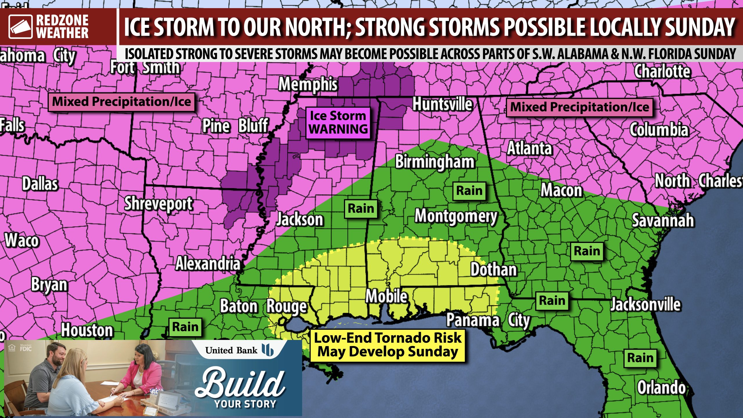
Current Alerts & Key Highlights
- Ice Storm Warning: In effect for Lauderdale, Colbert, and Franklin counties from midnight Saturday to 6 PM Sunday.
- Winter Weather Advisories & Winter Storm Watch: North of I-20 from early Saturday through 6 PM Sunday.
- Extreme Cold Watch: Southwestern counties from midnight to noon Monday.
- Up to 1 inch of ice accumulation possible in far northwest Alabama.
- Heavy rainfall (2-4 inches statewide, higher in north) could cause localized flooding.
- Possible severe thunderstorms Sunday in southern Alabama with 40-60 mph wind gusts and isolated tornado risk.
- Record-low temperatures expected Monday and Tuesday mornings (single digits in north).
“Driving conditions north of I-20 could be dangerous Saturday morning into the afternoon due to ice and freezing rain.”
— Jim Stefkovich, Meteorologist, Alabama Emergency Management Agency
Share this critical safety reminder on X/Twitter, Facebook, or Threads!
Detailed Forecast Breakdown
Precipitation begins in northern Alabama between 2 AM and 9 AM Saturday, spreading statewide through the afternoon and evening. Most heavy rain ends Sunday evening, but light snow flurries could linger into Monday morning.
North of I-20: Freezing rain and sleet dominate Saturday morning, transitioning to light snow or freezing drizzle Sunday afternoon. Far northwest counties could see up to 1 inch of ice and 1 inch of snow.
South of I-20: Mostly rain, but a line of strong thunderstorms is possible Sunday with damaging winds and a low tornado threat.
Temperatures plummet behind the system: Monday morning lows in the teens to low 20s, with wind chills below zero in the north. Tuesday morning could drop to single digits in northern counties.

Credit: Storm Prediction Center / Severe thunderstorm risk Sunday
Credit: RedZone Weather / Ice accumulation forecast
Winter Weather Safety Tips (Recommended by FEMA & NWS)
- Stay off roads if possible during ice events — bridges and overpasses freeze first.
- Prepare an emergency kit with blankets, food, water, and a flashlight.
- Protect pipes from freezing and keep pets indoors during extreme cold.
- Monitor official sources: Alabama EMA | NWS Birmingham
Stay informed and stay safe, Alabama! This is a rapidly evolving situation — check official channels for the latest updates.
Official Sources
- Alabama Emergency Management Agency (Primary Source)
- National Weather Service
- Storm Prediction Center
#Qalamkaar #BreakingNews #CurrentEvents #LatestNews #NewsToday #CurrentAffairs #USPolitics #WorldNews
:
"🚨 Major winter storm hitting Alabama this weekend! Ice, snow, severe storms & record cold ahead. Stay safe! #AlabamaWeather #WinterStorm2026 #BreakingNews #Qalamkaar Link"
Core Hashtags: #Qalamkaar #BreakingNews #CurrentEvents #NewsAnalysis #GlobalNews #LatestNews #NewsToday #InDepthAnalysis #TruthBehindNews


Post a Comment